Pages

Reshun chitral

Sunday, March 29, 2009

BABA SIYAR SHRINE


The famous chitrali poet BABA SIYAR shrine.

RESHUN


Saturday, March 21, 2009

BABA SIYAR POETERY

Yoorman Hamin"
composed by Baba Siyar, a Chitrali poet and mystic
I roam on the mountains as if I trod on hot ashes,The sword of love has stricken me; I made of my self a shield of two bones.Oh Yoorman Hamin!Oh Fairy I swear by God after seeing you there is no light,Night and day are alike dark to me, no dawn comes to me.Oh Yoorman Hamin!The curls of my bulbul are like rosebuds and maiden hair fern,Come sit by me and sing like a mynah or a bulbul.Oh Yoorman Hamin!Still I look at you; you turn away and look else where,My life is yours, why do look at my enemies?Oh Yoorman HaminYour long ringlets and your well-curled hair are like bedmushkYou bind up your locks to slay this lad.Oh Yoorman HaminI sigh day and night for the bulbul,I kiss your pearly ringlets in my dreams.Oh Yoorman HaminTranslated into English by Colonel Jhon Biddulph in 1876

Wednesday, March 18, 2009

SHANDUR CHITRAL


INTRODUCTION TO SHANDUR
The world famous Shandur pass is a bout 3738 meter an above sea level and lies midway between Chitral and Gilgit. The distance from Chitral is 147 Km and Gilgit is about 211Km. These areas remains snow covered in winter and turn into the green heaven during summer season. There is a big lake in the area. The traditional polo tournament played between Chitral and Gilgit teams in the month of hot July. Foreign tourist and native came to see the festival. The first recorded polo tournament played at this ground was in 1936, since then every year in July a grand polo tournament takes place at Shandur pass.

POLO AT SHANDUR
Shandur is the highest polo ground in the world, there is game of polo is played between Chitral and Gilgit in every year of July. The game originated in the dim and distant past in the high mountains of the Hindukush and Karakurum ranges. Amongst the horse loving peoples of Chitral, Gilgit and Hunza. here it is still played in its original form, a game as tough rough and hard, on man and horse as the surrounding mountains themselves. A game without rules or empire, a game with only a few agreed convention of play. Polo in Khowar called “Istoorghar” has been the traditional game of Chitral, as our motto is “we play polo the game of king and king of the games”. The game is commonly played to the music band comprising a big drum.

BACKGROUND INFORMATION
The Shandur Polo ground is in the district Chitral, and is situated at 72’ 35 east longitude and 36’ 06’ north la titude. It is bordered on the west by Yarkoon valley of Chitral and on the northerners by the valley of Gilgit district. It is dividing point between the caracara and the handout mountains ranges. The polo ground is about 168 Km from the main town Chitral and accessible by jeep. The road is closed during winter due to heavy snow.

Tuesday, March 17, 2009

Reshun goal picks


RESHUN VALLEY


Reshun is one of most beautiful valley of chitral.Reshun valley is situated in Chitral, N.W.F.P., Pakistan, its geographical coordinates are 36° 9' 0" North, 72° 6' 0" East and its original name (with diacritics) is Reshūn. See .
Reshun photos..Reshun is one of the most impressive places in the world.Reshun is one of the most impressive places in the world. Several high peaks rise above 6,000 m in the surroundings of Reshun valley. The valley provides spectacular views of some of the most beautiful and magnificent mountains of the world which include TERICHMER. Reshun goal is famous for its redish soil and redish mountains.The power house is also in reshun goal which supplies electricity to the upper chitral.
The history of Reshun is very famous and amazing background in every fields.The famous chitrali poet BABA SIYAR also belongs to this valley and the great chitrali singer MANSOOR ALI SHABAB also belongs to this valley.As much as the valley is famous for its beauty, the people of Reshun are noted for their friendliness and hospitality.The literacy rate of the Reshun valley is believed to be more than 80%. Virtually every child of the new generation studies up to at least high school level. Many pursue higher studies from prestigious colleges and Universities of pakistan and abroad.
The water of reshun is very pure and fresh,everyone feel surprise after looking fresh water.The mastuj road passes in between reshun valley.Really its amazing,magical valley attracting valley , dont miss it i you have chance in life to visit chitral.The Reshun valley is like Shangri La, and is also know as "The Valley Where you Live Forever" I called it my DREAM WORLD......karim

Friday, March 13, 2009

CHITRAL

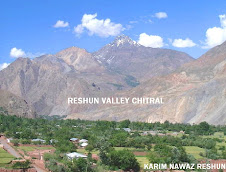
INTRODUCTION TO CHITRAL
Chitral is also known as Chitrar and Qashqar. Chitral is the heart of Marco Polo land, nestling between the rugged mountains of the Hindukush- ‘Slayers of the Hindus’. The region is a hidden Paradise in the Hindukush range, This interesting country of snow-peaked mountain ranges, ageless glaciers and deep green valleys through which flow the icy cold and crystal clear hill torrents from mountain springs and blue white glaciers has a natural charm and attraction of its own.
Truly speaking Chitral needs no introduction out side of the world, past and present, natural and the supernatural. It has been the familiar abode of giants and fairies since times of immemorial. Its high hills still preserve the huge caves where in inhibited the ancient giants called KASH and GABAR. It is the home of the mysterious khow tribes who fought the armies of Alexander the Great. Here lives the ancient Kalash tribe in some of its remote valleys, practicing a culture and beliefs, and way of life that date back to beyond history, are yet a problem unsolved for the experts of Human Sciences or Sociologists.
It is here in Chitral that stands the majestic Terichmir Peak, 5th highest in the world, towering over 25,000 ft. into the sky along with other sister peaks throwing a challenge to the adventure loving men of the world. Chitral like Gilgit is famous as the cradle of Polo, which is its national game. It is here in Chitral that the worlds famous and highest Polo ground stands right on the very summit of the over 12,250 ft Shandur Pass. It varies in elevation from about 1070 m (about 3500 ft) in the extreme south in Arandu to 7,690 m (25,230 ft) at the summit of Terich Mir in the Hindukush.

GEOGRAPHY & LOCATION
(Chitral, 35°53'15"N 71°48'01"E)
Chitral located in the North West of Pakistan is a beautiful valley in the Hindukush range of Mountains, Important for defense due to its location. Lying just south of the Hindukush mountain range, Chitral commands the main passes of these mountains and is therefore of great strategic importance in the defense of southern Asia. It is the northern most district of the NWFP. It is situated at about 366 kilometers from Peshawar. It is also connected to Peshawar by air. It enjoys a unique position in the region because of its location and potential. The district is strategically located in such a way that its neighbors include Afghanistan, Central Asian States, Northern Areas of Gilgit and China. Chitral is mostly inhabited by Chitrali people; however, it also has some Pushtoons in the southern areas and more importantly the Kalash people in beautiful valleys of Birir, Bomburet and Rambur of Chitral sub-division.

HIstory of chitral

Short History of ChitralThe Early history of Chitral is shrouded in mystery.This mountainous country which was first referred to as Kohistan or land of the mountains was said to be inhabited by a race called "Khows" speaking a separate language Khowar, or language of the Khows. Some people say that it was Khowistan - the abode of the Khows. Separate parts of the country came to be called Torkhow - Upper Khow, Mulkhow - Lower Khow, names which persist to the present day. An early Sanskrit inscription at a village called Barenis (27 miles away from Chitral) of about AD 900 records that the country was Buddhist, under King Jaipal of Kabul. It is believed that Upper Chitral was under Buddhist influence in the past and even today there are a few rocks in Torkhow area known as "Kalandar-i-Bohtni" (Mendicant of Stone). It is a figure of a stupa; the upper part of which has been cut into the figure of Buddha and may be of Chinese origin. No records of this period exist.Marco Polo, who passed through the Pamirs, referred to the country as Bolor. History relates that first a Chinese army and then an Arab (Mongols?) army invaded Chitral from the north by the Broghal pass when the upper part of the country is said to have been converted to Islam. The southern district remained non-Muslim till very late and were then converted to Islam. A Mongol tribe called Yarkhuns invaded Chitral via the Broghal pass and may have given their name to the Yarkun valley. They were opposed by Somalek, leader of the Khows. Another incursion is attributed to Changez Khan and his Tartars.Chitral nevertheless has remained an independent state for centuries with its own culture and language. In the late nineteenth century it became part of British India. It was a princely state in 1947, which acceded to Pakistan in that year. The rule of the Mehtar came to an end in 1954 and power was henceforth exercised by the political agent posted at Chitral. The state was merged into Pakistan in 1969. The recorded history of Chitral is divided into six epochs as follows:Iranian ruleThe Achemeanian Empire of Persia was extended to these regions during 400 BC. Its more than two thousand years since this empire receded but its supremacy was so strongly established that many Persian cultural traits are still in practice in Northern Areas as well as few parts of Chitral. In some valleys surrounding Chitral such as Wakhan, Shaghnan, and upper parts of Chitral people speak Persian language. Even Khowar, which is the native language of the local people (Khow), contains much borrowing from Persian.Zoroastrianism, an Old Persian religion, has also left behind some of its traces in this area. Traditions also tell about leaving of dead bodies unburied in caves in the wilderness or in the hollow of trees. Such practices were specific in this religion. A festival on 21st March (Nouroz) the first day in Persian calendar still prevails in Chitral. It is celebrated in few valleys every year. (Israr Chitral A historical sketchKushan ruleThe Kushan dynasty established its rule in this area in 200 AD. In the second century Kanishka the most powerful emperor of Kushan dynasty had extended his rule all over Northern India, probably as far as south Vindyas and all over the remote region up to Khotan beyond the Pamir pass. Chinese ruleThe Chinese extended their influence in the 4th century AD and remained in power until the 8th century. The rock inscription of Pakhtoridini near Maroi refers to Chinese rule. Another inscription in Barenis refers to the Kushans. According to Sir Aurel Stien, the inscription says that Jivarman ordered to make the pertinent drawing of a stupa. Such rock carvings have created confusion for writers like Buddulph and many others to believe that Chitral formed part of the last Hindu Shahi ruler of Kabul. It's also believed that the northern parts had embraced Islam by the end of 9th century when Arabs defeated Bahman, chief of the country. By the time of withdrawal of Arabs many people had accepted Islam. (Souvenir, 2nd Hindukush Cultural Conference, p.19-21)Kalash rule In the 11th century AD southern Chitral was invaded by the Kalash from Afghanistan, who occupied the country as far to the North as Barenis village, while the upper parts were under another chief Sumalik. some Kalash Chiefs Rojawai, such as Nagar Shah and Bala sing ruled Southern Chitral from 11th to 13th centuries A.D.Rais ruleIn the beginning of 11th century Shah Nadir Rais occupied southern Chitral and defeated the Kalash. Shah Nadir Rais extended his dominion from Gilgit to the present southern boundaries of Chitral. Rais family ruled over Chitral for about three hundred years when Katura family succeeded them.During the Rais rule in Chitral its boundaries extended from Narsut in the extreme south of the state to Gilgit in the east. The rulers had an effective council of chiefs of the local tribes to run the affairs of the country. The ruler of this family also worked for the dissemination of the teachings of Islam in the state.There were no regular state forces to defend the state frontiers so the local headmen and chiefs called all the persons of their tribes to fight for the state under the collective defense system. The Mehtar (ruler) had friendly relations with the rulers of surrounding countries. (Baig, Hindu Kush study series vol. two)Katur ruleThe Katur succeeded the Rais dynasty in 1595. Muhtaram Shah I was the founder of Kature rule in Chitral, whose descendants ruled over Chitral until 1969 when the State was merged as a district of NWFP.During the rule of Amirul Mulk in 1895, Umra Khan the chief of Jandool crossed the Lawari pass and invaded lower Chitral. As a result, there was fierce fighting in which the Mehtar of Chitral and British officers were besieged in Chitral fort for 42 days. Troops from Gilgit and Nowshera came to the rescue of the besieged fort and the British rule was extended over entire Chitral in April 1895. Shuja ul Mulk emerged as the ruler after the war who ruled for 42 years until 1936.During the Pakistan movement there was a campaign in Chitral in favor of independence. The people backed all India Muslim League and Mehtar Muzafarul Mulk openly declared his backing to the Pakistan movement. In May 1947 H.H. Muzafarul Mulk informed the Viceroy about his intention to join the new state of Pakistan. The accession instrument was signed on November 7, 1947.